Random Redditor asks: I do deliveries now and I’d be completely [clueless] without my GPS. How did you do it (before GPS)?
I delivered packages for a summer in the Houston area. Shitty job, but for reasons beyond the scope of this question. Short answer: I used a paper map.
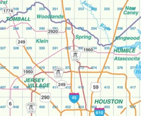
I was given a bunch of boxes in a general area, but I had to figure out where things went. For that, I would rely on my Key Map, a spiral-bound book mapping sections of the city. The spiral-binding was nice because the book laid flat. Each page had a smaller section of the overall map (see below). If I was traveling east-west, I would (mostly) flip to the adjacent page. North-south would I have to skip ahead about 20 pages – the edges are labeled with the page number. Once you got the gist, it was a pretty efficient way to get around. The book lagged real roads, so I never ended up in weird “traps” like I do in Google Maps and geocaching.
For new streets, I’d look up the general page in the index then use the street number to determine the approximate square based on the address number. The number being odd or even would help me know which side of the street to look. After I had worked an area for a couple of weeks, I had a very good sense of where things were and didn’t need the map as often. Cabbies are Jedi-masters at this.
The job was terrible because I was using my own car and putting about 250 – 275 miles a day on it. That’s hard on a vehicle. Houston in the summer is very hot. I also had to rent the radio and uniform from them. Take-home pay was a lot less than it seemed.